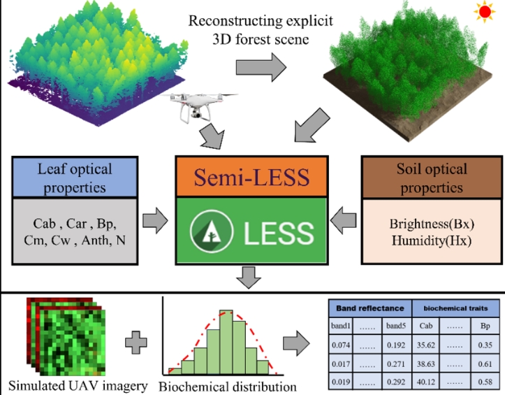
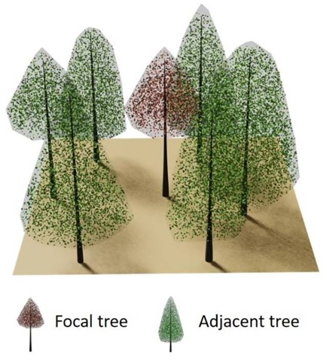
Publications
Table of contents:
Publications related to LESS by LESS team members
 |
 |
 |
 |
 |
 |
 |
|
 |
 |
 |
|
-
Luo, Y., Xie, D., Qi, J., Yan, G., Mu, X., 2024. Simulating High-Resolution Sun-Induced Chlorophyll Fluorescence Image of Three-Dimensional Canopy Based on Photon Mapping. Remote Sensing 16, 3783. https://doi.org/10.3390/rs16203783
-
Ouyang, L., Qi, J., Wang, Q., Jia, K., Cao, B., Zhao, W., 2024. MART3D: A Multilayer Heterogeneous 3D Radiative Transfer Framework for Characterizing Forest Disturbances.. Forests 15, 824.
-
Luo, Y., Xie, D., Qi, J., Zhou, K., Yan, G., Mu, X., 2023. LESS LiDAR: A Full-Waveform and Discrete-Return Multispectral LiDAR Simulator Based on Ray Tracing Algorithm. Remote Sensing 15, 4529. https://doi.org/10.3390/rs15184529
-
叶雨洋, 漆建波, 曹颖, 蒋靖怡, 2023. 基于LESS模型的异质植被冠层光合有效辐射吸收比与植被指数的关系研究. 遥感技术与应用 38, 51–65. https://doi.org/10.11873/j.issn.1004-0323.2023.1.0051
-
Zhou, K., Xie, D., Qi, J., Zhang, Z., Bo, X., Yan, G., Mu, X., 2023. Explicitly Reconstructing RAMI-V Scenes for Accurate 3-Dimensional Radiative Transfer Simulation Using the LESS Model. Journal of Remote Sensing 3, 0033. https://doi.org/10.34133/remotesensing.0033
-
Gao, G., Qi, J., Lin, S., Hu, R., Huang, H., 2023. Estimating plant area density of individual trees from discrete airborne laser scanning data using intensity information and path length distribution. International Journal of Applied Earth Observation and Geoinformation 118, 103281. https://doi.org/10.1016/j.jag.2023.103281
-
Qi, J., Xie, D., Guo, D. and Yan, G., 2017. A Large-Scale Emulation System for Realistic Three-Dimensional (3-D) Forest Simulation . IEEE Journal of Selected Topics in Applied Earth Observations and Remote Sensing, 10(11), pp.4834-4843.
-
Zhao, X., Liu, C., Qi, J., Yuan, L., Yu, Z., He, S., Huang, H., 2025. Evaluating Different Crown Reconstruction Approaches from Airborne LiDAR for Quantifying APAR Distribution Using a 3D Radiative Transfer Model. Remote Sensing 17, 53. https://doi.org/10.3390/rs17010053
-
漆建波, 谢东辉, 许月, 阎广建, 2019. 三维辐射传输模型LESS原理及其应用. 遥感技术与应用.
Publications and reasearches that have used LESS
2025
-
Han, Y., Wen, J., You, D., Xiao, Q., Liu, G., Tang, Y., Piao, S., Zhao, N., Liu, Q., 2025. Impacts of Topography on Daily Mean Albedo Estimation Over Snow-free Rugged Terrain. IEEE Geoscience and Remote Sensing Letters 1–1. https://doi.org/10.1109/LGRS.2025.3555608
-
Liu, W., Batelaan, O., Bruce, D., Wang, J., Gutierrez, H., Wang, H., Keegan-Treloar, R., Gou, J., Keane, R., Thompson, J., Guan, H., 2025. Integrating the Maximum Entropy Production model and airborne imagery for understorey evapotranspiration mapping. Journal of Hydrology 133076. https://doi.org/10.1016/j.jhydrol.2025.133076
-
Liang, D., Cao, B., Wang, Q., Qi, J., Jia, K., Zhao, W., Yan, K., 2025. A New Remote Sensing Index for the Detection of Multi-Type Forest Anomalies Based on Sentinel-2 Imagery. Forests 16, 497. https://doi.org/10.3390/f16030497
-
Han, D., Zhang, P., Liu, C., Liu, W., Bo, Z., Lin, Q., 2025. RaySHapke: A Bayesian Inversion Analysis of Lunar Surface Parameters Utilizing the Hapke Model Based on the Raytracing Shadowing Function. IEEE Trans. Geosci. Remote Sensing 1–1. https://doi.org/10.1109/TGRS.2025.3547908
-
Lai, Y., Mu, X., Fan, D., Zou, J., Xie, D., Yan, G., 2025. Methodology comparison for correcting woody component effects in leaf area index calculations from digital cover images in broadleaf forests. Remote Sensing of Environment 321, 114659. https://doi.org/10.1016/j.rse.2025.114659
-
Zhang, H., Zhao, D., Guo, Z., Guo, S., Bai, Q., Cao, H., Feng, S., Yu, F., Xu, T., 2025. Estimation of chlorophyll content in rice canopy leaves using 3D radiative transfer modeling and unmanned aerial hyperspectral images. Plant Methods 21, 26. https://doi.org/10.1186/s13007-025-01346-z
-
Zhao, D., Yang, G., Xu, T., Yu, F., Zhang, C., Cheng, Z., Ren, L., Yang, H., 2025. Dynamic Maize True Leaf Area Index Retrieval with KGCNN and TL and Integrated 3D Radiative Transfer Modeling for Crop Phenotyping. Plant Phenomics 100004. https://doi.org/10.1016/j.plaphe.2025.100004
-
Zhang, C., Chen, Z., Chen, R., Zhang, W., Zhao, D., Yang, G., Xu, B., Feng, H., Yang, H., 2025. Retrieving the chlorophyll content of individual apple trees by reducing canopy shadow impact via a 3D radiative transfer model and UAV multispectral imagery. Plant Phenomics 100015. https://doi.org/10.1016/j.plaphe.2025.100015
-
Frey, J., Schindler, Z., McClatchy, P., Morhart, C., Larysch, E., Seifert, T., 2025. The 3D reconstruction of wood and leaves from terrestrial laser scanning – a case study on PAR measurements below a solitary Malus domestica tree. Silva Fenn 59.
-
Xu, H., Huai, Y., Zhao, X., Meng, Q., Nie, X., Li, B., Lu, H., 2025. SK-TreePCN: Skeleton-Embedded Transformer Model for Point Cloud Completion of Individual Trees from Simulated to Real Data. Remote Sensing 17, 656.
-
Lin, X., Li, A., Bian, J., Zhang, Z., Nan, X., Chen, L., Bai, Y., Deng, Y., Li, S., 2025. Investigating the contribution of understory to radiative transfer simulations through reconstructing 3-D realistic temperate broadleaf forest scenes based on multi-platform laser scanning. Science of Remote Sensing 11, 100196.
2024
-
Oswald, D., Pourreza, A., Chakraborty, M., Khalsa, S.D.S., Brown, P.H., 2024. 3D radiative transfer modeling of almond canopy for nitrogen estimation by hyperspectral imaging. Precision Agric 26, 12.
-
Jiang, Y., Zhang, Z., He, H., Zhang, X., Feng, F., Xu, C., Zhang, M., Lafortezza, R., 2024. Research on Leaf Area Index Inversion Based on LESS 3D Radiative Transfer Model and Machine Learning Algorithms. Remote Sens. 16, 3627. https://doi.org/10.3390/rs16193627
-
Mu, X., Yang, Y., Xu, H., Guo, Y., Lai, Y., McVicar, T.R., Xie, D., Yan, G., 2024. Improvement of NDVI mixture model for fractional vegetation cover estimation with consideration of shaded vegetation and soil components. Remote Sens. Environ. 314, 114409. https://doi.org/10.1016/j.rse.2024.114409
-
Han, Y., Wen, J., You, D., Xiao, Q., Hao, D., Tang, Y., Piao, S., Liu, G., Liu, Q., 2024. Modeling Diurnal Variation of Land Surface Albedo over Rugged Terrain. IEEE Trans. Geosci. Remote Sens. 1–1.
-
尚可, 晏磊, 张飞舟, 褚君浩, 杨彬, 刘思远, Kevin TANSEY, 贾秀萍, Oleg DUBOVIK, 张子晗, 李飞, 2024. 从BRDF到BPDF:遥感反演基础模型的演进初探. 中国科学:信息科学 54, 2001–2020.
-
Yan, G., Xie, T., Hu, X., Cheng, S., Jiang, H., Hu, R., Li, F., Mu, X., Xie, D., 2024. Estimating the Leaf Area of Urban Individual Trees From Single-Scan Terrestrial Laser Scanner Based on Slant Leaf Area Index. IEEE Trans. Geosci. Remote Sensing 62, 1–16.
-
Wu, Z., Zheng, X., Ding, Y., Tao, Z., Sun, Y., Li, B., Chen, Xinmeng, Zhao, J., Liu, Y., Chen, Xinyu, Li, X., 2024. A Method for Retrieving Maize Fractional Vegetation Cover by Combining 3D Radiative Transfer Model and Transfer Learning. IEEE Journal of Selected Topics in Applied Earth Observations and Remote Sensing 1–27.
-
Zhao, D., Yang, H., Yang, G., Yu, F., Zhang, C., Chen, R., Tang, A., Zhang, W., Yang, C., Xu, T., 2024. Estimation of Maize Biomass at Multi-Growing Stage Using Stem and Leaf Separation Strategies with 3D Radiative Transfer Model and CNN Transfer Learning. Remote Sens. 16, 3000.
-
Ma, Y., He, T., McVicar, T.R., Liang, S., Liu, T., Peng, W., Song, D.-X., Tian, F., 2024. Quantifying how topography impacts vegetation indices at various spatial and temporal scales. Remote Sensing of Environment 312, 114311. https://doi.org/10.1016/j.rse.2024.114311
-
Wang, G., Jiang, L., Pan, F., Cui, H., Zhang, S., 2024. Modeling the top-of-atmosphere radiance of alpine snow with topographic effects explicitly solved. ISPRS Journal of Photogrammetry and Remote Sensing 216, 109–125. https://doi.org/10.1016/j.isprsjprs.2024.07.017
-
Hong, C., Li, D., Han, L., Du, X., Chen, S., Qi, J., Wang, C., Zhou, X., Qin, B., Jiang, H., Jia, K., Su, Z., 2024. Simulation and Analysis of Bidirectional Reflection Factors of Southern Evergreen Fruit Trees Based on 3D Radiative Transfer Model. Horticulturae 10, 790. https://doi.org/10.3390/horticulturae10080790
-
Jiang, Y., Cheng, Z., Yang, G., Zhao, D., Zhang, C., Xu, B., Feng, H., Feng, Z., Ren, L., Zhang, Y., Yang, H., 2024. Fine-Scale Quantification of the Effect of Maize Tassel on Canopy Reflectance with 3D Radiative Transfer Modeling. Remote Sens. 16, 2721.
-
Xian, Y., Wang, T., Du, Y., Letu, H., Qi, J., Li, D., 2024. A dataset of topographic correction coefficients for shortwave downward radiation over the Pan-Third Pole. Sci. Data 11, 779. https://doi.org/10.1038/s41597-024-03616-2
-
Chen, S., Xiao, P., Zhang, X., Liu, H., Wang, Y., Sun, L., Yin, G., 2024. Improved Snow-Covered Forest Bidirectional Reflectance Model Incorporating Canopy-Intercepted Snow and Atmospheric Effects. IEEE Trans. Geosci. Remote Sens. 1–1. https://doi.org/10.1109/TGRS.2024.3427818
-
Zhao, D., Xu, T., Henke, M., Yang, H., Zhang, C., Cheng, J., Yang, G., 2024. A method to rapidly construct 3D canopy scenes for maize and their spectral response evaluation. Comput. Electron. Agric. 224, 109138. https://doi.org/10.1016/j.compag.2024.109138
-
Lei, L., Li, Z., Yang, H., Hoey, T.B., Wu, J., Xu, B., Yang, X., Feng, H., Yang, G., 2024. A Two-Stage Leaf–Stem Separation Model for Maize With High Planting Density With Terrestrial, Backpack, and UAV-Based Laser Scanning. IEEE Trans. Geosci. Remote Sens. 62, 1–19.
-
Geng, J., Roujean, J.-L., Kuusk, A., Pang, Y., Tu, L., Zhang, T., Xu, J., Chen, J.M., 2024. A universal canopy gap fraction model for forests with various tree distributions based on Nilson’s models considering directional overlaps among crowns. Agricultural and Forest Meteorology 352, 110026. https://doi.org/10.1016/j.agrformet.2024.110026
-
Yu, W., Huang, H., Liu, Q., Wang, J., 2024. Integrating physical model and image simulations to correct topographic effects on surface reflectance. ISPRS Journal of Photogrammetry and Remote Sensing 211, 356–371. https://doi.org/10.1016/j.isprsjprs.2024.04.017
-
Lin, S., Li, L., Liu, S., Gao, G., Zhao, X., Chen, L., Qi, J., Shen, Q., Huang, H., 2024. Stratified burn severity assessment by integrating spaceborne spectral and waveform attributes in Great Xing’an Mountain. Remote Sensing of Environment 307, 114152. https://doi.org/10.1016/j.rse.2024.114152
-
Gao, S., Yan, K., Liu, J., Pu, J., Zou, D., Qi, J., Mu, X., Yan, G., 2024. Assessment of remote-sensed vegetation indices for estimating forest chlorophyll concentration. Ecological Indicators 162, 112001. https://doi.org/10.1016/j.ecolind.2024.112001
-
Dong, M., Liu, S., Jiang, R., Qi, J., de Solan, B., Comar, A., Li, L., Li, W., Ding, Y., Baret, F., 2024. Comparing and combining data-driven and model-driven approaches to monitor wheat green area index with high spatio-temporal resolution satellites. Remote Sensing of Environment 305, 114118. https://doi.org/10.1016/j.rse.2024.114118
-
Xie, J., Xie, D., Zhou, K., Yan, G., Mu, X., 2024. Analysis of the directional characteristics of the clumping index (CI) based on RAMI-V canopy scenes. J Remote Sens remotesensing.0133.
-
Tan, S., Zhang, Y., Qi, J., Su, Y., Ma, Q., Qiu, J., 2024. Exploring the Potential of GEDI in Characterizing Tree Height Composition based on Advanced Radiative Transfer Model Simulations. J Remote Sens remotesensing.0132.
-
Ye, X., Ren, H., Wang, P., Duan, Y., Zhu, J., 2024. Urban LST Retrieval From the Ultrahigh Spatial Resolution Remote Sensing Data. IEEE Geoscience and Remote Sensing Letters 21, 1–5.
-
Wang, Y., Gu, Y., Tang, J., Guo, B., Warner, T.A., Guo, C., Zheng, H., Hosoi, F., Cheng, T., Zhu, Y., Cao, W., Yao, X., 2024. Quantify Wheat Canopy Leaf Angle Distribution Using Terrestrial Laser Scanning Data. IEEE Transactions on Geoscience and Remote Sensing 1–1.
-
Li, X., Li, L., Ni, W., Mu, X., Wu, X., Vaglio Laurin, G., Vangi, E., Stereńczak, K., Chirici, G., Yu, S., Huang, H., 2024. Validating GEDI tree canopy cover product across forest types using co-registered aerial LiDAR data. ISPRS Journal of Photogrammetry and Remote Sensing 207, 326–337.
-
Li, W., Yan, G., Mu, X., Tong, Y., Zhou, K., Xie, D., 2024. Modeling the hotspot effect for vegetation canopies based on path length distribution. Remote Sensing of Environment 303, 113985.
-
Yang, K., Yan, K., Zhang, X., Zhong, R., Chi, H., Liu, J., Ma, X., Wang, Y., 2024. Assessing FY-3D MERSI-Ⅱ Observations for Vegetation Dynamics Monitoring: A Performance Test of Land Surface Reflectance. IEEE Transactions on Geoscience and Remote Sensing 1–1. https://doi.org/10.1109/TGRS.2023.3348997
-
Ran, Y., Song, S., Hou, X., Chen, Y., Chen, Z., Gong, W., 2024. Multi-echo hyperspectral reflectance extraction method based on full waveform hyperspectral LiDAR. ISPRS Journal of Photogrammetry and Remote Sensing 207, 43–56. https://doi.org/10.1016/j.isprsjprs.2023.11.019
2023
-
Lei, L., Li, Z., Yang, G., Yang, H., 2023. High-Throughput Extraction of the Distributions of Leaf Base and Inclination Angles of Maize in the Field. IEEE Transactions on Geoscience and Remote Sensing 61, 1–28. https://doi.org/10.1109/TGRS.2023.3332869
-
Han, D., Liu, J., Zhang, R., Liu, Z., Guo, T., Jiang, H., Wang, J., Zhao, H., Ren, S., Yang, P., 2023. Evaluation of the SAIL Radiative Transfer Model for Simulating Canopy Reflectance of Row Crop Canopies. Remote Sensing 15, 5433. https://doi.org/10.3390/rs15235433
-
Liu, X., Chen, Y., Mu, X., Yan, G., Xie, D., Ma, X., Yan, K., Song, W., Liu, Z., 2023. Correction for the Sun-Angle Effect on the NDVI Based on Path Length. IEEE Transactions on Geoscience and Remote Sensing 1–1. https://doi.org/10.1109/TGRS.2023.3322780
-
Lin, X., Li, A., Bian, J., Zhang, Z., Lei, G., Chen, L., Qi, J., 2023. Reconstruction of a large-scale realistic three-dimensional (3-D) mountain forest scene for radiative transfer simulations. GIScience & Remote Sensing 60, 2261993. https://doi.org/10.1080/15481603.2023.2261993
-
Zeng, Y., Hao, D., Park, T., Zhu, P., Huete, A., Myneni, R., Knyazikhin, Y., Qi, J., Nemani, R.R., Li, F., Huang, J., Gao, Y., Li, B., Ji, F., Köhler, P., Frankenberg, C., Berry, J.A., Chen, M., 2023. Structural complexity biases vegetation greenness measures. Nature Ecology Evolution 1–9.
-
Yang, S., Peng, N., Zhai, D., Tao, Y., He, Q., Mu, X., Li, Y., Fan, W., 2023. Fisheye-based forest LAI field measurements for remote sensing validation at high spatial resolution. IEEE Geoscience and Remote Sensing Letters 1–1. https://doi.org/10.1109/LGRS.2023.3308369
-
Gao, S., Zhong, R., Yan, K., Ma, X., Chen, X., Pu, J., Gao, S., Qi, J., Yin, G. and Myneni, R.B., 2023. Evaluating the saturation effect of vegetation indices in forests using 3D radiative transfer simulations and satellite observations. Remote Sensing of Environment, 295, p.113665.
-
Chen, S., Xiao, P., Zhang, X., Qi, J., Yin, G., Ma, W. and Liu, H., 2023. Simulating snow-covered forest bidirectional reflectance by extending hybrid geometric optical–radiative transfer model. Remote Sensing of Environment, 296, p.113713.
-
Wu, Q., Yang, S.S. and Jiang, J., Impacts of Clumping Effect on Canopy Reflectance Using 3-D Radiative Transfer Modeling. Frontiers in Forests and Global Change, 6, p.1106773.
-
Zhang, J., Sun, R., Xiao, Z., Zhao, L. and Xie, D., 2023. AM–GM Algorithm for Evaluating, Analyzing, and Correcting the Spatial Scaling Bias of the Leaf Area Index. Remote Sensing, 15(12), p.3068.
-
Cheng, J., Yang, H., Qi, J., Han, S., Sun, Z., Feng, H., Chen, R., Zhang, C., Li, J., Yang, G., 2023. Evaluation of the effect of leaf spatial aggregation on chlorophyll content retrieval in open-canopy apple orchards. International Journal of Applied Earth Observation and Geoinformation 121, 103367.
-
Xian, Y., Wang, T., Cheng, W., Letu, H., Du, Y., Leng, W., 2023. A Uniform Model for Correcting Shortwave Downward Radiation Over Rugged Terrain at Various Scales. IEEE Transactions on Geoscience and Remote Sensing 1–1.
-
Zhang, Q., Wang, D., Gastellu-Etchegorry, J.-P., Yang, J., Qian, Y., 2023. Impact of 3-D structures on directional effective emissivity in urban areas based on DART model. Building and Environment 239, 110410.
-
Li, H., Yan, K., Gao, S., Ma, X., Zeng, Y., Li, W., Yin, G., Mu, X., Yan, G., Myneni, R.B., 2023. A Novel Inversion Approach for the Kernel-Driven BRDF Model for Heterogeneous Pixels. Journal of Remote Sensing 3, 0038.
-
Ye, X., Ren, H., Wang, P., Zhu, Jinshun, Zhu, Jian, 2023. Thermal Infrared Radiance Transfer Modeling of the Urban Landscape at Ultrahigh Spatial Resolution. IEEE Geoscience and Remote Sensing Letters 20, 1–5.
-
Huang, H., Qi, J., Li, L., 2023. Enhanced Branch Simulation to Improve RAPID in Optical Region Using RAMI Scenes. Journal of Remote Sensing 3, 0039. https://doi.org/10.34133/remotesensing.0039
-
Zhu, W., You, D., Wen, J., Tang, Y., Gong, B., Han, Y., 2023. Evaluation of Linear Kernel-Driven BRDF Models over Snow-Free Rugged Terrain. Remote Sensing 15, 786. https://doi.org/10.3390/rs15030786
-
Liu, Z., Long, J., Lin, H., Du, K., Xu, X., Liu, H., Yang, P., Zhang, T., Ye, Z., 2023. Interpretation and Mapping Tree Crown Diameter Using Spatial Heterogeneity in Relation to the Radiative Transfer Model Extracted from GF-2 Images in Planted Boreal Forest Ecosystems. Remote Sensing 15, 1806. https://doi.org/10.3390/rs15071806
-
张腾, 游冬琴, 闻建光, 唐勇, 2023. 二向反射遥感反演最优角度采样方法研究. 遥感技术与应用 38, 66–77. https://doi.org/10.11873/j.issn.1004-0323.2023.1.0066
2022
-
Tong, Y., Jiao, Z., Zhang, X., Yin, S., Guo, J., 2022. An Improved Method for Estimating Clumping Index by Digital Hemispheric Photography With Field Measurements. IEEE Geoscience and Remote Sensing Letters 19, 1–5. https://doi.org/10.1109/LGRS.2022.3216274
-
Geng, J., Tu, L., Chen, J.M., Roujean, J.-L., Yuan, G., Hu, R., Huang, J., Zhang, C., Ye, Z., Qu, X., Yu, M., Zhu, Y., Tian, Q., 2022. Variation of Clumping Index With Zenith Angle for Forest Canopies. IEEE Transactions on Geoscience and Remote Sensing 60, 1–11. https://doi.org/10.1109/TGRS.2022.3226154
-
Cheng, J., Yang, H., Qi, J., Sun, Z., Han, S., Feng, H., Jiang, J., Xu, W., Li, Z., Yang, G., Zhao, C., 2022. Estimating canopy-scale chlorophyll content in apple orchards using a 3D radiative transfer model and UAV multispectral imagery. Computers and Electronics in Agriculture 202, 107401. https://doi.org/10.1016/j.compag.2022.107401
-
Dai, Z., Ding, Y., Xu, C., Chen, Y., Liu, L., 2022. Evaluation of the impact of crop residue on fractional vegetation cover estimation by vegetation indices over conservation tillage cropland: a simulation study. International Journal of Remote Sensing 43, 6463–6482. https://doi.org/10.1080/01431161.2022.2139649
-
Feng, B., Nie, S., Wang, C., Xi, X., Wang, J., Zhou, G., Wang, H., 2022. Exploring the Potential of UAV LiDAR Data for Trunk Point Extraction and Direct DBH Measurement. Remote Sens. 14, 2753.
-
Song, W., Mu, X., McVicar, T.R., Knyazikhin, Y., Liu, X., Wang, L., Niu, Z., Yan, G., 2022. Global quasi-daily fractional vegetation cover estimated from the DSCOVR EPIC directional hotspot dataset. Remote Sens. Environ. 269, 112835.
-
Lai, Y., Mu, X., Li, W., Zou, J., Bian, Y., Zhou, K., Hu, R., Li, L., Xie, D., Yan, G., 2022. Correcting for the clumping effect in leaf area index calculations using one-dimensional fractal dimension. Remote Sens. Environ. 281, 113259.
-
Geng, J., Chen, J.M., Fan, W., Tu, L., Pang, Y., Yuan, G., Xu, L., Zhu, C., Zhang, T., Zhang, C., Ye, Z., Zhu, Y., Li, Z., 2022. Application of a Hypergeometric Model in Simulating Canopy Gap Fraction and BRF for Forest Plantations on Sloping Terrains. IEEE J. Sel. Top. Appl. Earth Obs. Remote Sens. 15, 2901–2913.
-
Li, X., Tong, T., Luo, T., Wang, J., Rao, Y., Li, L., Jin, D., Wu, D., Huang, H., 2022. Retrieving the Infected Area of Pine Wilt Disease-Disturbed Pine Forests from Medium-Resolution Satellite Images Using the Stochastic Radiative Transfer Theory. Remote Sens. 14, 1526.
-
Song, W., Zhao, T., Mu, X., Zhong, B., Zhao, J., Yan, G., Wang, L., Niu, Z., 2022. Using a Vegetation Index-Based Mixture Model to Estimate Fractional Vegetation Cover Products by Jointly Using Multiple Satellite Data: Method and Feasibility Analysis. Forests 13, 691.
-
Bian, Z., Wu, S., Roujean, J.-L., Cao, B., Li, H., Yin, G., Du, Y., Xiao, Q., Liu, Q., 2022. A TIR forest reflectance and transmittance (FRT) model for directional temperatures with structural and thermal stratification. Remote Sens. Environ. 268, 112749.
2021
-
Li, W., Mu, X., 2021. Using fractal dimension to correct clumping effect in leaf area index measurement by digital cover photography. Agricultural and Forest Meteorology. 311, 108695.
-
Chu, Q., Yan, G., Qi, J., Mu, X., Li, L., Tong, Y., Zhou, Y., Liu, Y., Xie, D., Wild, M., 2021. Quantitative Analysis of Terrain Reflected Solar Radiation in Snow-Covered Mountains: A Case Study in Southeastern Tibetan Plateau. Journal of Geophysical Research: Atmospheres 126, e2020JD034294.
-
Yan, K., Zhang, Y., Tong, Y., Zeng, Y., Pu, J., Gao, S., Li, L., Mu, X., Yan, G., Rautiainen, M., Knyazikhin, Y., Myneni, R.B., 2021. Modeling the radiation regime of a discontinuous canopy based on the stochastic radiative transport theory: Modification, evaluation and validation. Remote Sensing of Environment. 267, 112728.
-
Cao, B., Qi, J., Chen, E., Xiao, Q., Liu, Q., Li, Z., 2021. Fine scale optical remote sensing experiment of mixed stand over complex terrain (FOREST) in the Genhe Reserve Area: objective, observation and a case study. International Journal of Digital Earth 14, 1411–1432. https://doi.org/10.1080/17538947.2021.1968047
-
Bian, Z., Roujean, J.L., Cao, B., Du, Y., Li, H., Gamet, P., Fang, J., Xiao, Q. and Liu, Q., 2021. Modeling the directional anisotropy of fine-scale TIR emissions over tree and crop canopies based on UAV measurements. Remote Sensing of Environment, 252, p.112150.
-
Chi, H., Yan, K., Yang, K., Du, S., Li, H., Qi, J., Zhou, W., 2021. Evaluation of Topographic Correction Models Based on 3-D Radiative Transfer Simulation. IEEE Geoscience and Remote Sensing Letters 1–5.
-
Yan K , Gao S , Chi H , et al. Evaluation of the Vegetation-Index-Based Dimidiate Pixel Model for Fractional Vegetation Cover Estimation. IEEE Transactions on Geoscience and Remote Sensing, 2021, PP(99):1-14.
-
Ma, Y., He, T., Li, A., Li, S., 2021. Evaluation and Intercomparison of Topographic Correction Methods Based on Landsat Images and Simulated Data. Remote Sensing 13, 4120.
-
许月, 谢东辉, 漆建波, 阎广建, 穆西晗, 张吴明, 20210526. 基于计算机模拟模型LESS的落叶松林木质元素影响分析. 遥感学报 25, 1138–1151.
2020
-
Pu, J., Yan, K., Zhou, G., Lei, Y., Zhu, Y., Guo, D., Li, H., Xu, L., Knyazikhin, Y., Myneni, R.B., 2020. Evaluation of the MODIS LAI/FPAR Algorithm Based on 3D-RTM Simulations: A Case Study of Grassland. Remote Sensing 12, 3391. https://doi.org/10.3390/rs12203391
-
Li, X., Huang, H., Shabanov, N.V., Chen, L., Yan, K. and Shi, J., 2020. Extending the stochastic radiative transfer theory to simulate BRF over forests with heterogeneous distribution of damaged foliage inside of tree crowns. Remote Sensing of Environment, 250, p.112040.
-
Yan, G., Chu, Q., Tong, Y., Mu, X., Qi, J., Zhou, Y., Liu, Y., Wang, T., Xie, D., Zhang, W. and Yan, K., 2020. An Operational Method for Validating the Downward Shortwave Radiation Over Rugged Terrains. IEEE Transactions on Geoscience and Remote Sensing.
2019
-
Chen, S., Liu, L., Zhang, X., Liu, X., Chen, X., Qian, X., Xu, Y., Xie, D., 2019. Retrieval of the Fraction of Radiation Absorbed by Photosynthetic Components (FAPARgreen) for Forest using a Triple-Source Leaf-Wood-Soil Layer Approach. Remote Sensing 11, 2471. https://doi.org/10.3390/rs11212471
-
Jiao, Z.-H., Ren, H., Mu, X., Zhao, J., Wang, T., Dong, J., n.d. Evaluation of Four Sky View Factor Algorithms using Digital Surface and Elevation Model Data. Earth and Space Science. https://doi.org/10.1029/2018EA000475
2018
- Li, L., Mu, X., Macfarlane, C., Song, W., Chen, J., Yan, K. and Yan, G., 2018. A half-Gaussian fitting method for estimating fractional vegetation cover of corn crops using unmanned aerial vehicle images. Agricultural and Forest Meteorology, 262, pp.379-390.